

Above: Map Room, BC Cartographic Commission, ca. 1947, Private Collection
Special Exhibit | ‘i’kw’at tthu nuts’umat | Exposition spéciale
Human and Other Geographies
False Horizons : Cartographic Fictions
[ Preempting the 51st state ]
Secrets of the BC Cartographic Commission
The exhibition False Horizons brings to light a previously unknown chapter in the cartographic and geopolitical history of the Southern Gulf Islands. In 2023, researchers and amateur historians on Gabriola and nearby Mudge Island uncovered documents and subterranean infrastructure pointing to a covert Cold War operation: from 1940 to 1959, the British Columbia Cartographic Commission (BCCC) maintained a classified underground facility on Gabriola, dedicated to the fabrication of false maps for the region. The goal, it appears, was both strategic and psychological—to scramble enemy navigation systems, mislead aerial reconnaissance, and subtly reshape the geopolitical imaginary of the coast.
This discovery not only reveals a fascinating piece of regional history, but raises urgent questions about the status of maps as instruments of truth, ideology, and control. The cartographic archive has long held a paradoxical role: it promises objective knowledge—grids, coordinates, and measured elevation—yet it is always an artefact of power. As this exhibition demonstrates, the BCCC’s work during the early Cold War years was less about representation and more about misdirection, producing deliberate distortions of coastlines, settlement locations, shipping channels, and topographic features. Maps were drawn with slight errors, fictitious islands were added or relocated, and known landmarks were renamed or erased altogether.
In presenting archival facsimiles, reconstructed map-room dioramas, oral history recordings, and contemporary artistic responses, False Horizons explores the aesthetics of cartographic deception and the psychological dimensions of Cold War paranoia. The underground nature of the BCCC’s Gabriola office—literally buried beneath the landscape it sought to reimagine—speaks to a deeper tension between surface and secrecy, presence and erasure, accuracy and illusion.
Several artists in the exhibition respond directly to this legacy, treating the map not as a neutral tool but as a medium of fiction and latency. Their works—installations, speculative atlases, and performance scores—mirror the logic of decoy and substitution. One re-creates a navigational map of the Strait of Georgia using magnetic filings and iron-rich Gabriola soil, another renders the fictive islands of the BCCC documents as digital terra incognita. Through these responses, the exhibition links the Cold War cartographic project to contemporary practices of counter-mapping and spatial resistance.
But beyond the historical intrigue lies a more disquieting proposition: that the very ground we inhabit may be unstable, not geologically but epistemologically. What if the maps we trust were never intended to guide us, but to keep others lost? What if the history of place is inseparable from a history of misrepresentation?
False Horizons invites viewers to navigate this shifting terrain. It offers not a stable narrative, but a set of coordinates through which to think about territory, secrecy, and the enduring political power of the map. In recovering this obscure and covert initiative, the exhibition proposes that even the most familiar landscapes may still contain buried intentions, and that every line drawn on a map is also, in some sense, a line drawn through memory, imagination, and control.

Above: Master Archive, Cartographic Commission, ca. 1962, Private Collection
_.png)
Above: Analysis Room, Cartographic Commission, ca. 1962, Private Collection

Above: Secret Entrance, Cartographic Commission Mudge Island Facility, ca. 1962, Private Collection
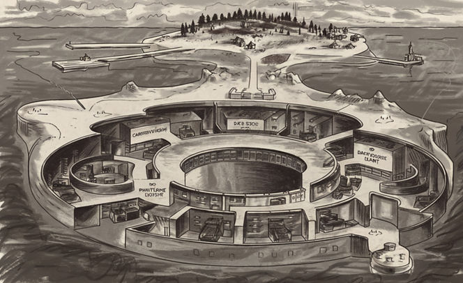
Above: Subterranean Cartography Centre Layout Sketch, ca. 1949, Private Collection
On Loan from the Pudget Sound Museum of Modern Art :
Animal Baptismals and Baptismal Cloaks
of the Pacific North West
August 1 to November 30, 2025

This exhibition, on loan from the Pudget Sound Museum of Modern Art, is perhaps one of the most controversial projects we have undertaken in recent years. Along with its partner exhibition Animal Baptismals ( see under the category 'Special Exhibions' it ventures into a fraught terrain of historical entanglements, symbolic transpositions, and ritual ambiguity.
To speak of the “Pacific Northwest” is of course already to invoke a geopolitical imaginary shaped by settler-colonial cartographies—an uneven space whose cultural histories have often been rendered through a predominantly U.S.-centric lens. Yet it is precisely in this space of layered narratives and unresolved tensions that the exhibition seeks to intervene.
In the rugged and symbolically rich cultures of the 'Pacific Northwest' during the late 19th century, the convergence of Indigenous cosmology and Christian theology produced artifacts of profound psychological and spiritual significance—none more so than the Animal Baptismal Cloaks displayed in this exhibition.
These ceremonial garments represent more than aesthetic or anthropological interest; they mark a critical juncture in the development of meaning, where the logos of Christianity met the animistic worldviews of First Nations peoples in an attempt—however fraught—to bring order, hierarchy, and redemption into alignment with the natural world.
Christianity, with its emphasis on the soul's fall and potential for salvation, introduced the radical notion that not only humans but animals could be seen as spiritual beings in need of moral and metaphysical guidance. In its dual role as non-redeemed counterpart to the human, as mere life (bios) resource to hold dominion over, and as symbolic of the purity of the world before the fall, the animal has been a problematic presence — its semblances to the human always fundamentally scandalous, and hence in need of reinterpretation, or suppression. Are these cloaks (also known as Schabracken, from the Hungarian 'csáprág' meaning saddle cloth) indicators of a culture of celebrating or of subjugating life?
In the hands of Indigenous artisans, this doctrine was neither passively accepted nor entirely rejected—it was transformed. These cloaks suggest a deep understanding of the sacred responsibilities between humans and animals, mediated through ritual and symbol, where spiritual hierarchy coexists with ecological reciprocity.
Such artifacts compel us to confront the difficult truth: that meaning is born in the tension between systems, and that spiritual order—even across cultures—requires both discipline and reverence to flourish.
The baptism of animals—an obscure and controversial practice, often regarded as anomalous within both Christian and Indigenous frameworks—provides a lens through which deeper, more subterranean dynamics of power, belief, and classification can be discerned. Much like the animal trials of late medieval Europe, these rites were not merely curious spectacles but moments of intense symbolic labor: attempts to draw the boundaries of the human, the spiritual, and the rational. They represent a liminal zone between animist recognition and ecclesiastical regulation, between the wild and the ordained.
The cloaks themselves, gathered here from disparate sources across what colonial discourse has named the Pacific Northwest, function as both textile and text—indexing a process of cultural translation and subjugation, but also resistance. Their animal forms are not costumes; they are thresholds. To clothe a beaver, orca, or raven in baptismal garb is to perform a double gesture: to inscribe the animal into a human sacrament, and to render the sacred absurd—perhaps even uncanny.
Psychoanalytically, one might read these rites as manifestations of what Freud called the “return of the repressed”—the persistence of animistic logic beneath the surface of monotheistic doctrine. Baptizing an animal does not simply elevate it; it displaces the human subject. Lacan’s mirror stage finds a strange echo here: the animal, in its garb, becomes a distorted reflection, an object through which the human attempts to secure its own symbolic order—but never without a residue of anxiety.
For First Nations communities, whose cosmologies often include a profoundly different relation to the animal world—one in which kinship, not dominion, is foundational—the Christian rite of baptism can be both an imposition and a site of negotiation. The cloaks stand at this crossroads. They reveal the contested ground where spiritual ontologies meet, merge, and sometimes conflict. They are not neutral artifacts but contested garments, draped in the invisible forces of colonization, conversion, and cultural persistence.
This exhibition does not attempt resolution. Instead, it opens a space for confrontation, reflection, and critical inquiry. It invites us to consider how rituals—especially those performed upon nonhuman bodies—serve not only theological purposes but also juridical and psychological ones. To baptize an animal is to rewrite the terms of the sacred; to cloak it is to dress an epistemological wound.
We welcome viewers into this charged dialogue between worldviews, knowing that discomfort is part of the passage. The cloaks, uncanny in their beauty and troubling in their implication, remain as witnesses to the strange, sorrowful, and sometimes sublime entanglement of belief systems and the lives they sought to sanctify—or silence.


Above: Animal Baptismal, ca. 1860, Private Collection
Directly related to the presentation of Animal Baptismal Cloaks, this Special Exhibition showcasing the fascinating world of early Animal Baptism paraphernalia from the mid-1880s. Here, you will discover an array of unique items including full-sized baptismals, and related artifacts that highlight the cultural practices of the time. A publication that explores their history and lineages is currently being prepared
Please note that while the Institute is extremely pleased to be able to display these objects, we are committed to repatriating them to their communities of origin at the earliest posssible date.

Above: Several West Coast Immersion Baptismals,
Anonymous, Cedar, ca. 1810-1895

"[Re] Evaluating Rural Rituals "